
Aircraft Detection at Planetary Scale
Introduction
By: Adam Van Etten, Jake Shermeyer, Ramesh Nair, and Justin Davis
On a typical day, there are greater than 10,000 aircraft (commercial, private, and military) in flight at any given time. The precise departure (point A) and destination (point B) locations, as well as the timing of flight activity, provide critically important information for myriad industries. For instance, in the defense and intelligence sector, being able to identify how many aircraft were stationed at one foreign government’s airbase (point A) and how many are gone the next day may reveal insights as to why an allied government’s airbase (point B) just received a new fleet on their tarmac.
On the commercial side, understanding how many aircraft landed in a city on a specific day can help predict economic trends and assess the impacts of world events - such as the quantity of aircraft present for large sporting or entertainment events. Satellite imagery is a powerful information source for this type of aircraft detection. Combine automated satellite scans of airfields with a global news reporting large language model, and you can start to get a feed of insights, linking the patterns of politics and economies with global air traffic.
Scale
Aircraft detection with satellite imagery is nothing new. In fact, aircraft detection on the tarmac is an archetypal use case for remote sensing machine learning. Until now, though, aircraft detection has been limited to a select number of airfields with sporadic coverage and cadence. Planet’s satellites, on the other hand, scan all of Earth’s landmass on a near-daily basis, so we are now able to mitigate those limitations, leveraging novel machine learning techniques with global PlanetScope coverage to drastically scale global aircraft detection.
The need for greater scale in aircraft detection is difficult to overstate. More than one hundred thousand commercial and military flights take place each day, as planes transport people and cargo to nearly fifty thousand airports across the globe. Some sites collect and share publicly available data on this complex matrix of movement. But not every flight is recorded, and not every plane is public.
Monitoring aircraft activity is vital for economic, defense, and intelligence purposes, but current methods rely on tedious and expensive processes, especially at scale. The rapid pace of geopolitical developments and sheer volume of data means that analyzing airfields manually is no longer feasible, especially in conflict/sensitive zones where aircraft movements aren’t publicly reported.
Planet’s new Aircraft Detection Analytic Feed automates daily detection of aircraft by leveraging a machine learning model trained using PlanetScope and SkySat data. It precisely identifies aircraft ≥25 meters in length or wingspan across airfields globally. It represents the first attempt at global detection of large aircraft on a near-daily basis and offers a scalable solution for analysis at scale. This presents a massive and unprecedented opportunity for analysts with or without geospatial expertise. Historical daily counts of aircraft broken down by size and location enables pattern-of-life analyses to be conducted, highlighting when anomalous behavior is detected. This can indicate events taking place or even actions to come.
Keep reading for more information or watch our on-demand webinar webinar.
Our Approach
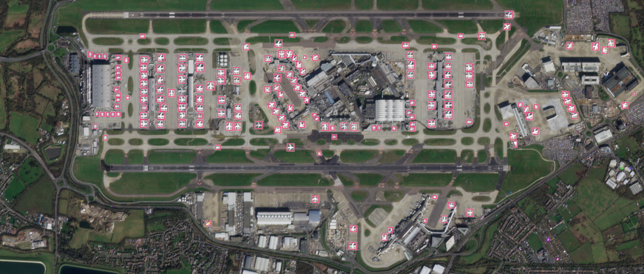
Our Aircraft Detection service leverages a supervised object detection model, trained on PlanetScope imagery to detect aircraft at rest on an airfield/airport tarmac. Precise labeling of aircraft can be a challenging task in medium-resolution PlanetScope imagery, so we use high-resolution SkySat imagery collected within 3 minutes of a PlanetScope scene (see Figure 1). This approach enables us to label on high-resolution imagery, then apply those high fidelity labels to medium-resolution PlanetScope data. The vast majority of aircraft are static on a 3-minute timeframe, but around ~2% of aircraft move between the two collections, and we remove those labels in our quality control phase.
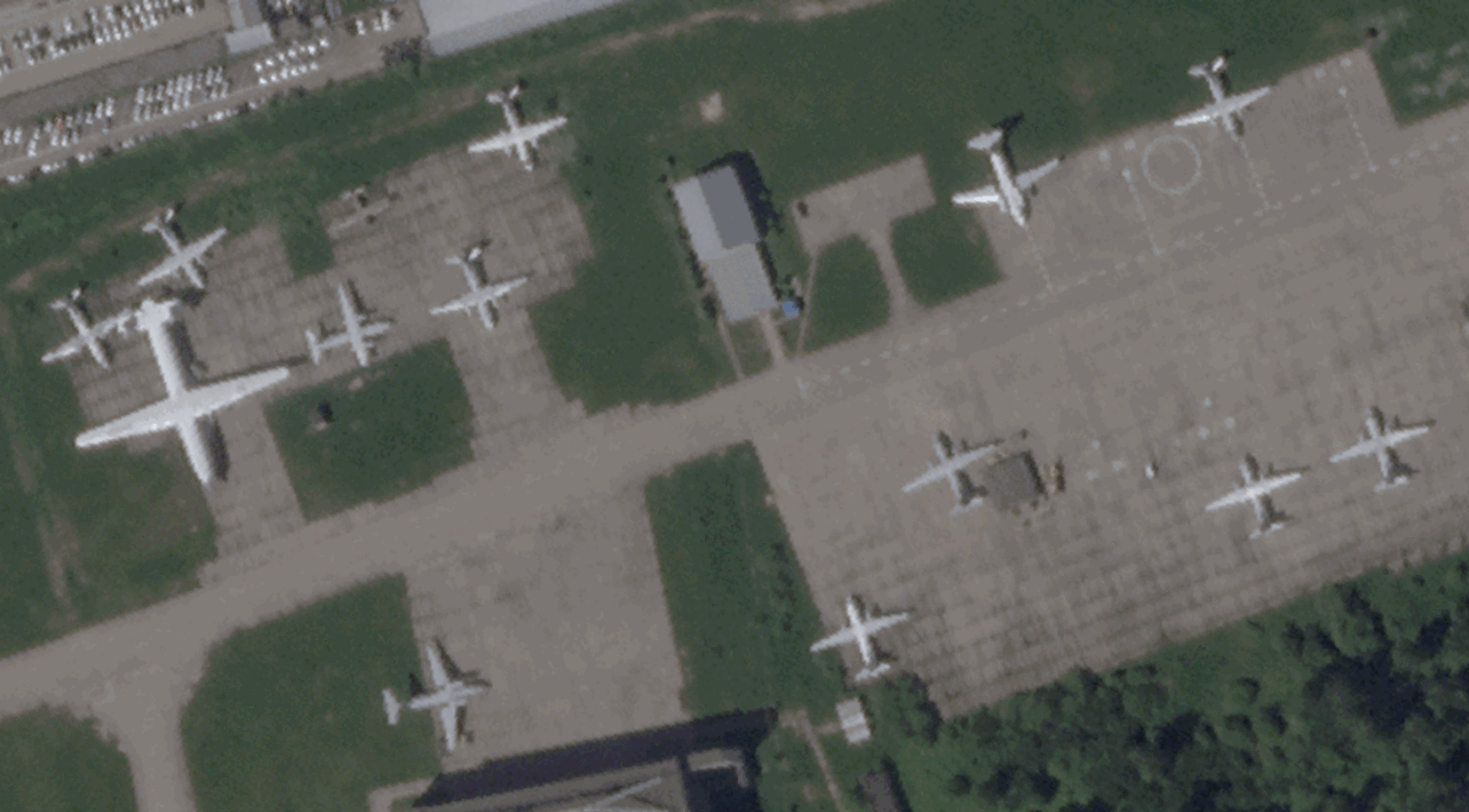
Figure 1. SkySat aircraft labels are applied to concurrent PlanetScope imagery.
With this approach, we collected over 800 concurrent (or “crossover”) image pairs for labeling. After significant experimentation with many different model architectures, we determined that aircraft <25m in length or wingspan are too small to be reliably detected in medium resolution imagery, so we elected to focus on aircraft this size or greater. Splitting the dataset into 85% training / 15% testing, we generated a training dataset consisting of ~15,000 labels, roughly evenly split between civilian and military types. This is by no means an enormous dataset, so expansion of the label corpus would likely yield a performance boost.
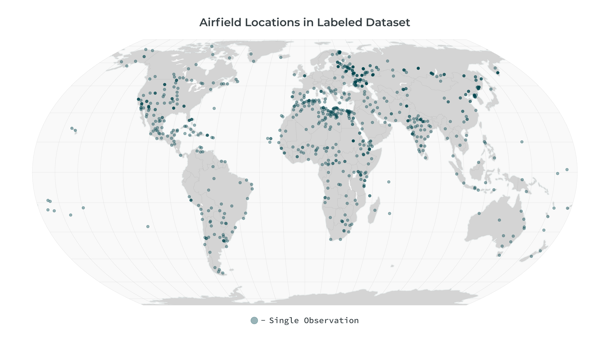
Figure 2. Airfield locations in the labeled dataset.
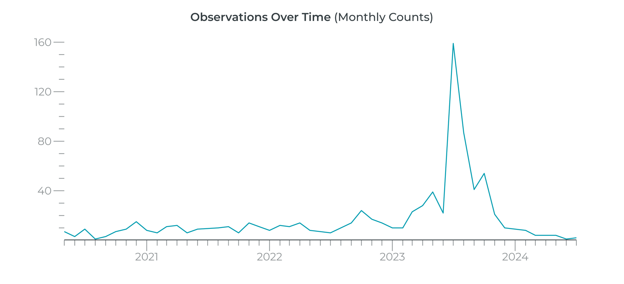
Figure 3. Observation dates, covering multiple years and every season. A concerted effort was made in 2023 to leverage SkySat capacity to capture data over airfields to ensure we had a healthy amount of data to leverage.
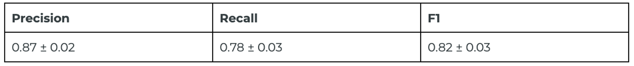
We utilize a deep learning object detection model optimized for Planet’s medium resolution imagery, which runs at sufficient speed so that we are free to analyze as many airports and airstrips as desired. The model achieves an F1 score of 0.82 for aircraft detection on our globally distributed test set. Reported errors are at the 1σ level, computed via bootstrap resampling of the test set.
High resolution SkySat imagery can be leveraged for more than just training data generation. Occasionally, additional scrutiny will be required to understand exactly what’s going on at a given airfield. An example is provided in Figure 3, which shows a consistent “missed” detection with our PlanetScope model. Yet closer inspection of this airfield with SkySat revealed that this apparent “miss” was in fact merely a painting on the tarmac. The ability to rapidly probe targeted areas much deeper with SkySat is a highly valuable complement to the ubiquitous daily coverage of PlanetScope.
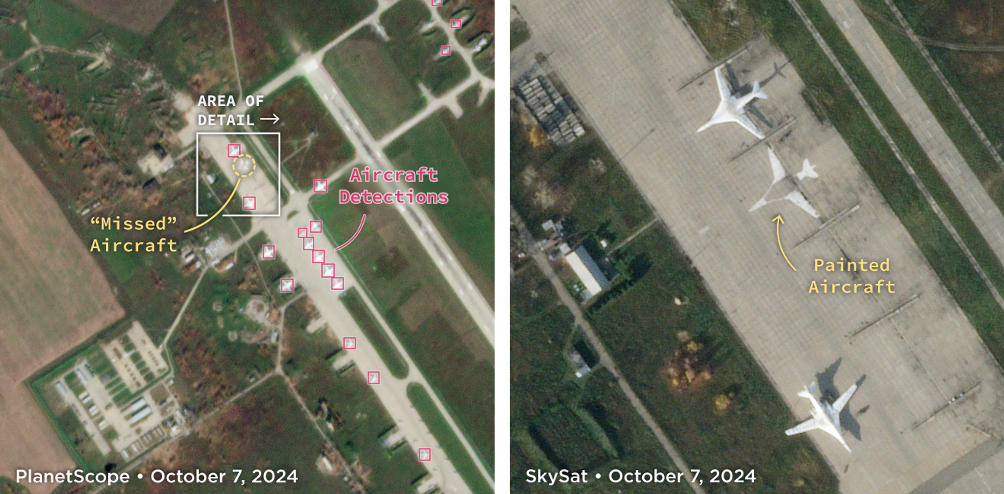
Figure 4. PlanetScope (left) detections showing a “missed” aircraft in the upper left. High-resolution SkySat imagery (right) illustrating that only paint exists at this location.
Loading Video...
Figure 5. Animation showing analysis of a large corpus of global detections.
Next Steps
Our solution extends significantly beyond the archetypal problem of counting aircraft on the tarmac. We track behavior at an approximately daily cadence by quantifying the fraction of aircraft that moved or remained static. Furthermore, interactive dashboards enable on-the-fly time series analysis, outlier categorization, and trend aggregation. We’ve integrated a global news LLM into this process to further enlighten our users. Detected outliers are subsequently probed for correlation to regional events. We’ve demonstrated this capability in our Agile EO Webinar. Watch it on demand here!
Ready to Get Started
Connect with a member of our Sales team. We'll help you find the right products and pricing for your needs.