
Earth Day: Agile Science in the Anthropocene
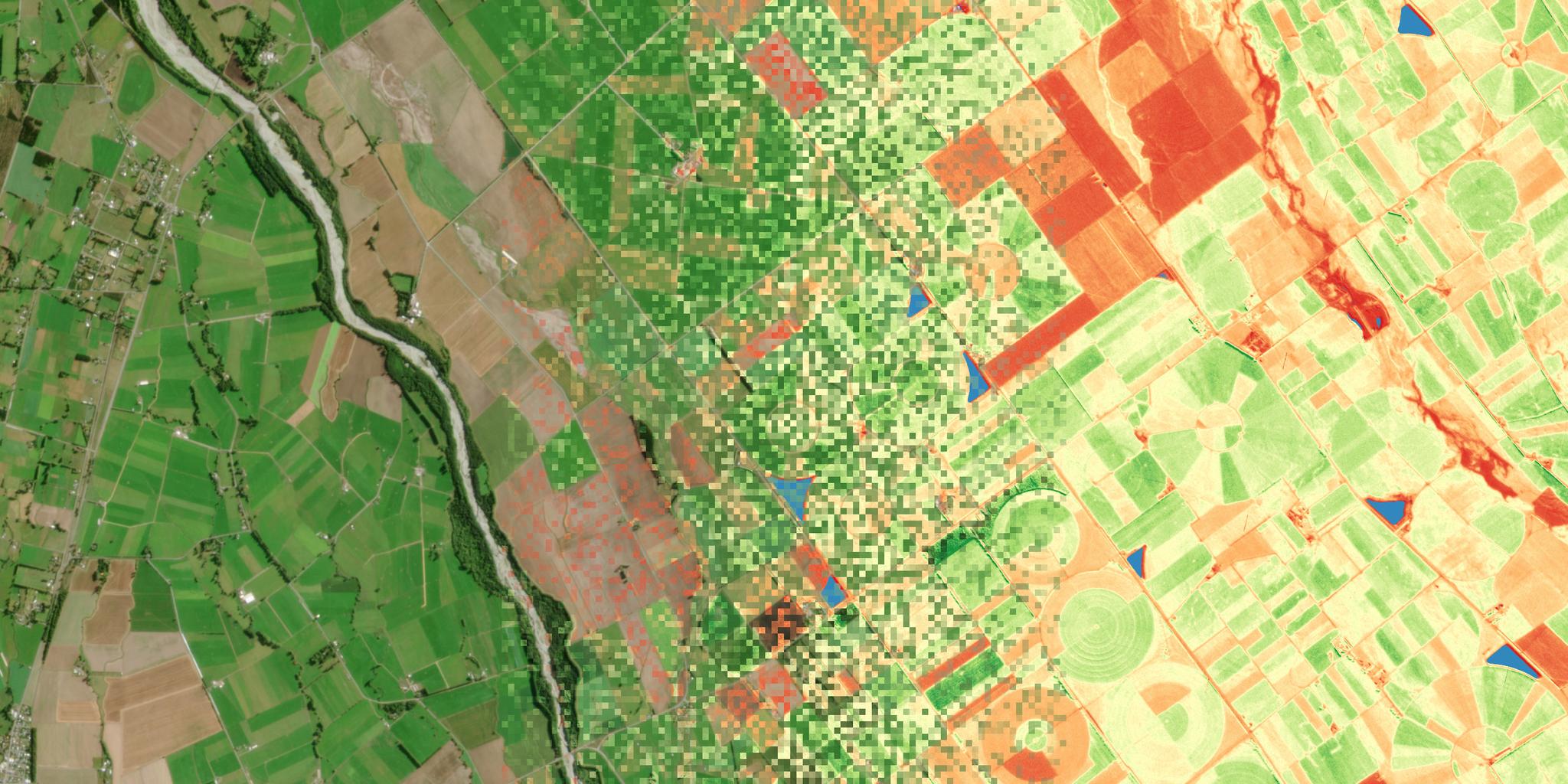
True color (left) and Chlrophyll Index red edge (right) data for an area of pasture on New Zealand’s South Island, collected on March 21, 2020. © 2020, Planet Labs Inc. All Rights Reserved.
StoriesOn the first Earth Day in 1970—with boot prints on the moon fresh in our memory—humanity was buzzing with a desire to make a conscious, global effort to be better stewards of our planet, and endowed with the confidence that we can do great things. It was not an accident that, just two years later, the first Landsat satellite launched, and the era of global remote sensing began. Today, on Earth Day's 50th anniversary, Landsat, Sentinel, Planet and scores of other government- or commercially-operated satellites collect a staggering amount of data about the surface of our planet. The story it tells, is grave. Earth has entered the “Anthropocene,” a new geological epoch defined by the enormous reach of humanity over the biosphere. Humans now directly occupy or control the fundamental ecological processes of roughly 50 percent of the Earth’s land surface, and have a pervasive and poorly quantified influence on the oceans. Humanity has altered nearly all of our planet’s biogeochemical cycles, even in the most remote ecosystems. Most prominently, atmospheric carbon dioxide concentrations likely exceed levels experienced throughout the Pleistocene, beginning 2.5 million years ago. And now, we are all grappling with the unique global COVID-19 crisis. The value of data-driven decision making has never been higher. Data must be analyzed, interpreted and synthesized to foster decision making. Where does this process begin? If you travel upstream from a database or a decision support tool—to the point where the pixels are first touched by a human mind—there is often a scientist, asking questions. Being curious. Designing a new sensor or writing a new piece of software. To celebrate Earth Day, and the third anniversary of Planet’s Education and Research Program, I wanted to share a few of the requests our team gets, each day, from university students and researchers across the world. Rosa Aguilar, MSc. and Professor Monika Kuffer, from the University of Twente in the Netherlands, wrote, in 2018: “We have several ongoing research projects where we would like to use Planet data: mapping of urban structure types and their relation to urban heat islands, mapping of urban growth, understanding of spatial factors driving this development, mapping urban poverty of African cities, comparing machine learning and deep learning methods, and generating in class exercises based on outcomes of these research projects with international Masters students.” This April, Aguilar and Kuffer published a portion of this work in the journal Remote Sensing, leveraging Planet data to better measure progress toward the U.N.’s Sustainable Development Goal 11: Sustainable Cities and Communities. Aguilar is now working toward a Ph.D. From the Education and Research Program to Planet’s partnerships with NASA and the European Space Agency, the scientific community is developing a manifold understanding of the coupled human-Earth system. In her master's thesis at the Naval Postgraduate School, Katherine Rice used transfer learning—a neural network approach—to first detect, and then classify different types of maritime vessels. Tongshu Zheng, a Ph.D. student at Duke University, recently developed a novel machine learning algorithm to analyze particulate aerosols—a type of air pollution—over cities in China. Suzanne Palmer, a Lecturer at the University of the West Indies, recently asked: “I’d like to assess the effects of the installation of artificial structures on shallow coral reef habitats—what is their impact on the surrounding environment over time?” [caption id="attachment_144771" align="aligncenter" width="1600"]
Ready to Get Started
Connect with a member of our Sales team. We'll help you find the right products and pricing for your needs