
EO-Powered Energy and Infrastructure Intelligence for Earth Day 2025
The strong message of Earth Day 2025, “Our Power, Our Planet,” calls for global action. Asia leads the solar landscape, with 61% of the worldwide solar installed land area. This provides a significant advantage for Asian governments to leverage Planet’s near-daily data to further modernize their energy systems, strengthen infrastructure, and reduce harmful emissions.
EO-powered Energy Intelligence makes it possible to make informed energy decisions based on accurate and timely data. This approach is especially useful for countries in the Asia-Pacific region, where air pollution, often caused by harmful emissions, continues to affect public health. With Planet’s satellite data, government agencies in Asia-Pacific can plan energy projects that lower pollution emissions and improve daily life.
How Can Planet's Satellite Data Power Energy and Infrastructure Intelligence in Asia-Pacific?
Broad area management using satellite data provides governments with a clear and comprehensive view of landscape and open waters. It improves planning across broad areas, even in locations that are difficult to reach or where ground-level data are unavailable.
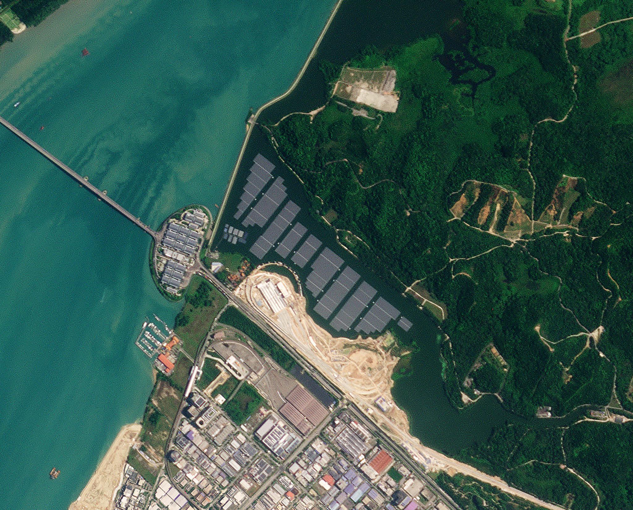
PlanetScope image of one of the largest inland floating solar photovoltaic (PV) systems in the world located in Tengeh Reservoir, Singapore captured on April 8, 2023. © 2023, Planet Labs PBC. All Rights Reserved.
Planning Renewable Energy Development
Satellite data can be processed to provide geospatial insights to help energy ministries, land management agencies, or investors strategically assess possible energy infrastructure sites before making decisions. Efficient site selection decreases resources spent on surveying and can reduce disruption to communities. It also helps avoid areas with environmental or land access conflicts, making timelines more manageable.
Energy Infrastructure Management & Performance Monitoring
By analyzing satellite images over time, Asia-Pacific governments can monitor the growth of energy facilities in their region and with Planet’s analytical feeds vegetation data can even show changes outside facilities, helping to reduce risks, like wildfires. This capability also enables facility managers to evaluate trends across time. Proactive facility monitoring improves maintenance planning and long-term reliability.
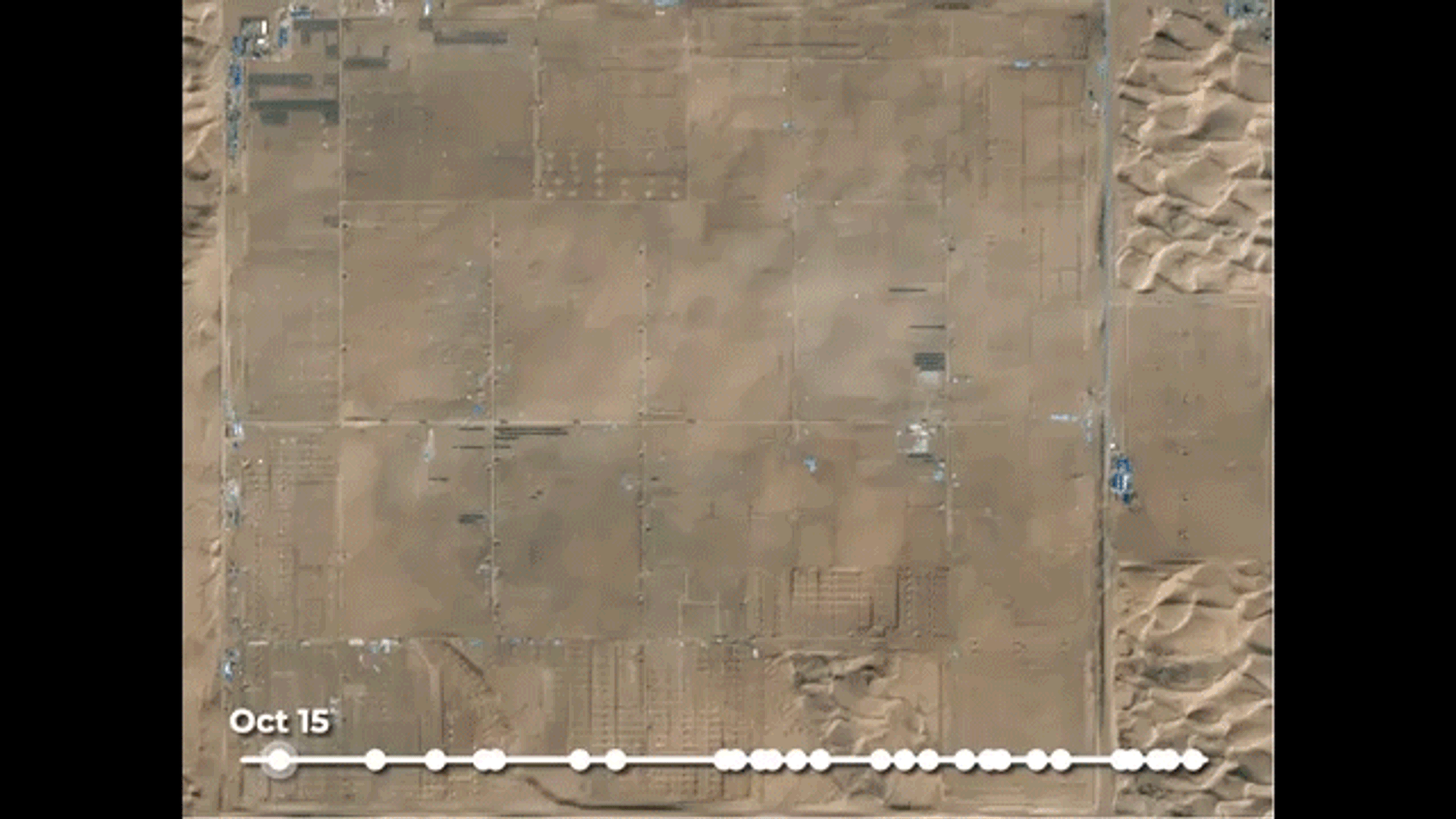
Time series of the construction of a horse-shaped solar farm near Ordos, Inner Mongolia, China captured from October 15 to December 30, 2018. © 2018, Planet Labs PBC. All Rights Reserved.
Clean Energy for Healthier Cities
Air pollution continues to pose a significant health risk in many Asian cities, including India. In a recent discussion, G. Satish Raju, Planet’s Senior Manager for Industry Accounts in Asia-Pacific, shared how Planet’s broad area monitoring and near-daily EO data can support India’s efforts to combat air pollution. This high-frequency and wide-coverage data provides timely insights into land use, urban growth, and industrial activity. EO-derived insights are essential for shaping effective policies and programs to reduce pollution, including the strategic transition to clean energy.
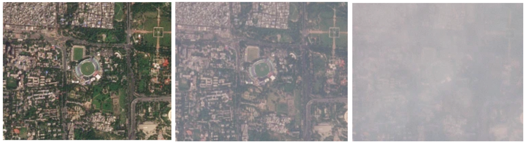
Time series of the air pollution over Arun Jaitley Stadium, Delhi captured from October 3 to October 15, 2023 (left to right), © 2023, Planet Labs PBC. All Rights Reserved.
Powering Government Decisions with EO Insights
1. Smarter Policy Formulation
Planet’s satellite data can provide detailed information on where energy sources are available and where new projects can be built. This gives governments the tools to set data-informed goals, design effective programs, and prioritize areas with the greatest need for air quality improvement. Supporting the shift away from fossil fuel-based power plants can reduce harmful emissions such as particulate matter, which is a contributor to unhealthy air.
2. Geospatial Data for Impact Assessment
By combining EO-derived air quality data with the locations of energy sources, decision-makers can compare air quality in these areas over time. Planet’s historical archive and near-daily insights enable progress tracking and adjusting plans in the national, regional, or local levels.
3. Minimize Environmental Stress
Energy infrastructures require vast lands which raises environmental concerns. With detailed and timely data, governments can monitor the impact of energy facilities in ecosystems and ensure compliance with environmental regulations, and avoid regulatory fines that could harm both their bottom line and brand reputation.
4. Disaster Risk and Management
Planet Monitoring and Planet Tasking enable detection of natural hazards, such as floods and droughts, that could affect infrastructure and energy supply chain. A key example of Planet data use in emergency management was the unprecedented flooding in Australia where Planet insights and analytics helped inform critical decisions and assess flood damage. Planet satellite data was also leveraged across the Philippines, in response to typhoons, enabling faster and more efficient action by authorities and disaster management teams.
With this capability, government agencies and planners can assess disaster risks, prepare infrastructure response plans, allocate budgets more effectively, and minimize potential damages.
EO Data for Earth Day 2025 and Beyond
As early adopters of renewables, Asia-Pacific governments can meaningfully use Planet satellite data to guide energy and infrastructure decisions to improve public services, reduce health risks from air pollution, and lessen impact to natural resources.
The tools are available. The data is ready. What’s needed now is action.
Ready to Get Started
Connect with a member of our Sales team. We'll help you find the right products and pricing for your needs