
Planet Data Helps Scientists Track the Impacts of Natural Disasters
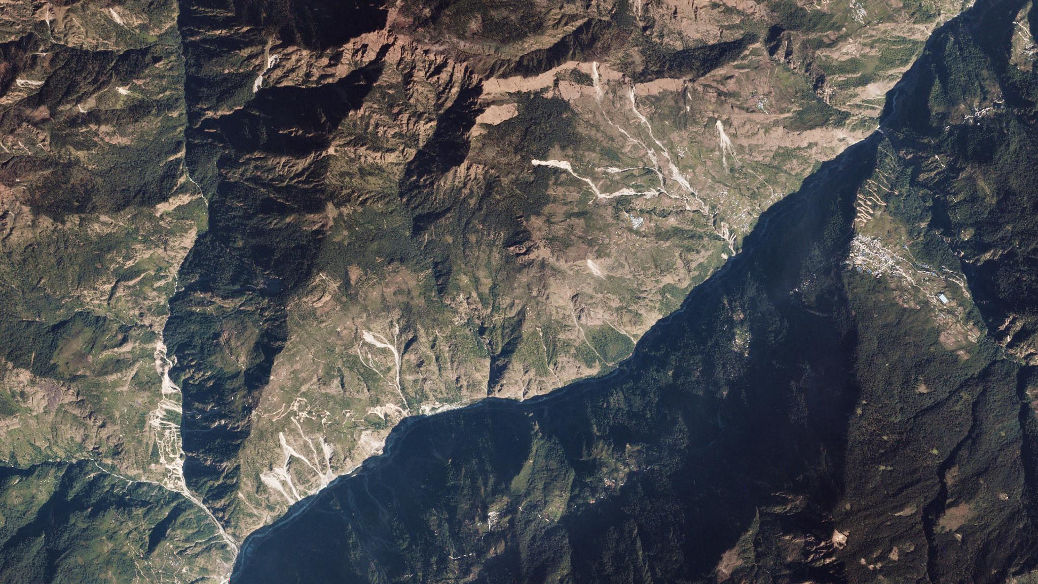
Landslides above the Trishuli Ganga River, Nepal, imaged by a Planet on October 27, 2019. © 2019, Planet Labs Inc. All Rights Reserved.
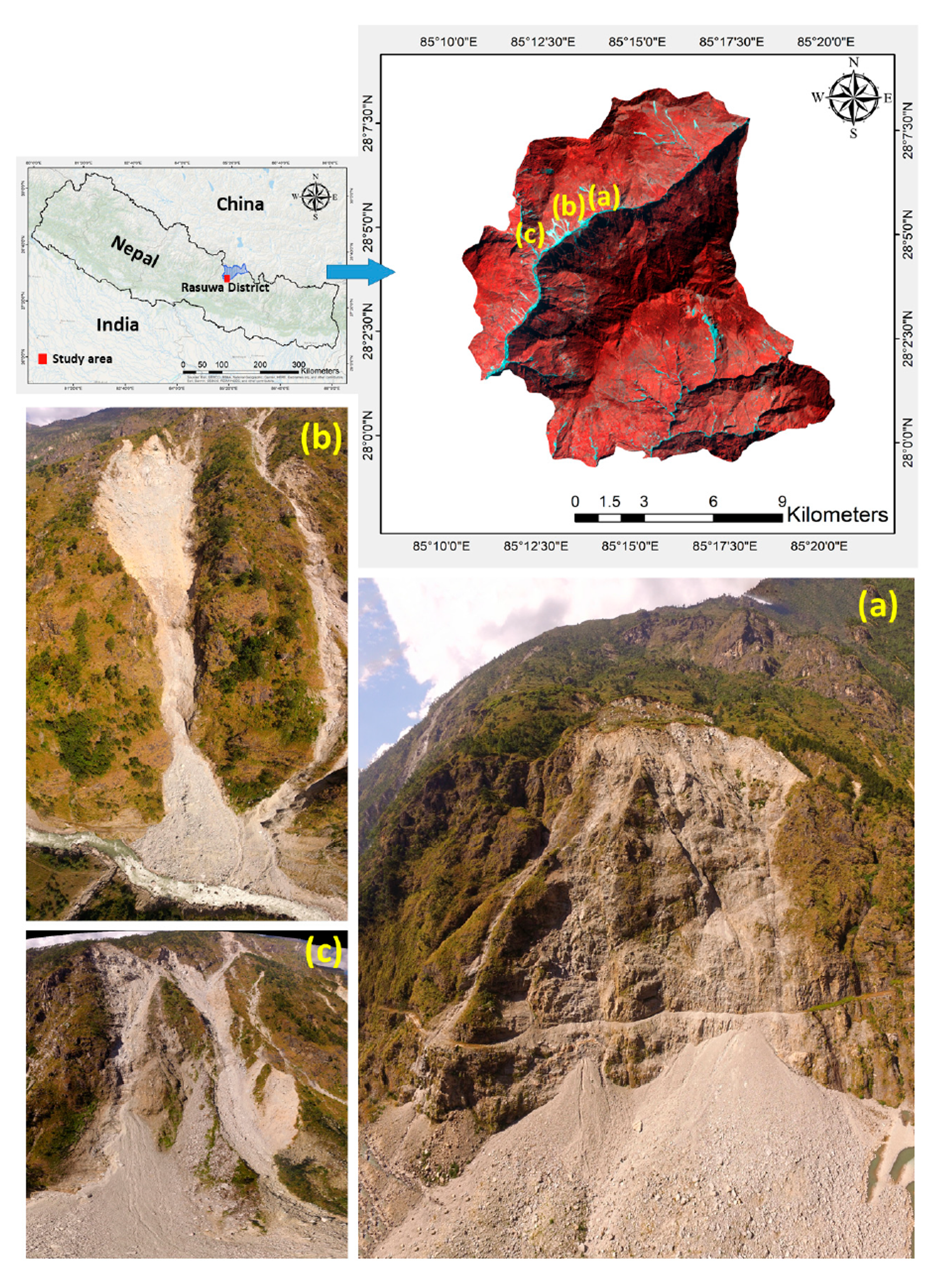
StoriesNatural disasters pose a threat to life, infrastructure and natural resources in mountainous regions. From 2004–2017, there were nearly 5,500 landslides worldwide, resulting in the loss of nearly 60,000 human lives. In the U.S. alone, landslides cause $2–4 billion in damages annually. As a part of an effort to help us better understand, prepare and respond to landslides, an international group led by Sepideh Tavakkoli Piralilou at the University of Salzburg utilized PlanetScope data in combination with satellite-based radar and airborne LiDAR to train machine learning algorithms to automatically identify landslides in the Himalayas. They gained access to PlanetScope through Planet's Education and Research program, which offers non-commercial data access to researchers. They chose the Himalayas as their focus area as large earthquakes hit the region frequently, repeatedly triggering massive landslides that can result in hundreds of lives lost and significant economic damage each time. In particular, they looked for landslides triggered by a magnitude 7.8 earthquake that hit Nepal in April 2015. This quake resulted in nearly 200 landslides, killing approximately 9,000 people and injuring 22,000 more. PlanetScope allowed these researchers to detect landslides that were unable to be mapped in the field because of the extremely rugged terrain. They created Normalized Differential Vegetation (NDVI) maps using the combination of PlanetScope RGB and near-IR bands, allowing them “to better distinguish between landslide and non-landslide events,” the study authors state in their paper. Using a combination of machine learning algorithms rather than just a single approach—as most researchers have done previously—they were able to create models with nearly 90 percent accuracy. Piralilou’s study helps emphasize how data fusion unlocks more information and potential than any single data source alone. Models like these can be expanded to larger geographic areas, allowing a better look into the contributing factors behind landslides around the world. Understanding the complex variability between weather and climate over time in particular will help to improve models of landslide occurrence and impact, which can help inform organizations and governments responding to the crisis. Understanding where landslides are mostly likely to occur can help local governments and populations better prepare with infrastructure and disaster response plans. Detecting and mapping landslides rapidly after they happen will aid in first responder efforts, quickly showing where the damage has occurred and what routes to the location are still accessible. [caption id="attachment_144875" align="aligncenter" width="960"]
Ready to Get Started
Connect with a member of our Sales team. We'll help you find the right products and pricing for your needs.