Planet Superpowers: Looking Closer
Look at a place, event, or object in much closer detail than previously captured.
Earth observation (EO) satellites have revolutionized our understanding of our planet, providing invaluable data for various applications. Satellite data allows organizations to see and monitor change across broad geographies and timescales — and take informed action.
However, sometimes the devil is in the details; and in these cases a more precise view is needed. High-resolution satellite imagery captures images with incredible clarity, revealing features as small as a tree. Let’s take a look at how this data allows organizations across private and public sectors to look closer at the areas that matter most.
EO Data and Broad Area Management
EO data is central to broad area management, which is the practice of monitoring, measuring, and reporting on assets, whether natural or man-made, across broad geographies and timescales.
And when broad area monitoring is combined with high-resolution tasking, organizations are able to have a comprehensive and detailed view — allowing them to see and understand the unknowns.
Planet provides solutions that support both — PlanetScope® Monitoring offers a continuous, daily view of the world; and Planet SkySat® Tasking captures images with exceptionally high resolution. Together, they create an invaluable view of activity across the Earth.
This pair of PlanetScope images, from August 17 and 26, 2023, captures wildfire damage (dark purple-black areas) across the Alexandroúpolis region in Greece. The white box indicates the town of Pefka, featured in the next set of images.
The Power of High-Resolution Tasking
At 50 cm resolution, SkySat Tasking provides organizations with near real-time intelligence to proactively identify blind spots, anticipate events, and have confidence in the next mission-critical decision.
- Precision and detail: High-resolution satellite imagery offers unparalleled detail, allowing users to zoom in and analyze objects as small as vehicles or individual trees. This level of precision is important for applications that require fine-grained insights, such as infrastructure planning or archaeological surveys.
- Timeliness and responsiveness: With the ability to task satellites on-demand and rapidly capture high-resolution images, users gain access to near real-time information when they need it most. This agility is particularly critical in emergency response scenarios, where every minute counts in decision-making and resource allocation.
- Comprehensive coverage: By complementing high-resolution SkySat imagery with rapid-revisit PlanetScope data, operators can provide comprehensive coverage of vast areas while still capturing important details. This hybrid approach ensures that users have access to both the big picture and the finer details they need to make informed decisions.

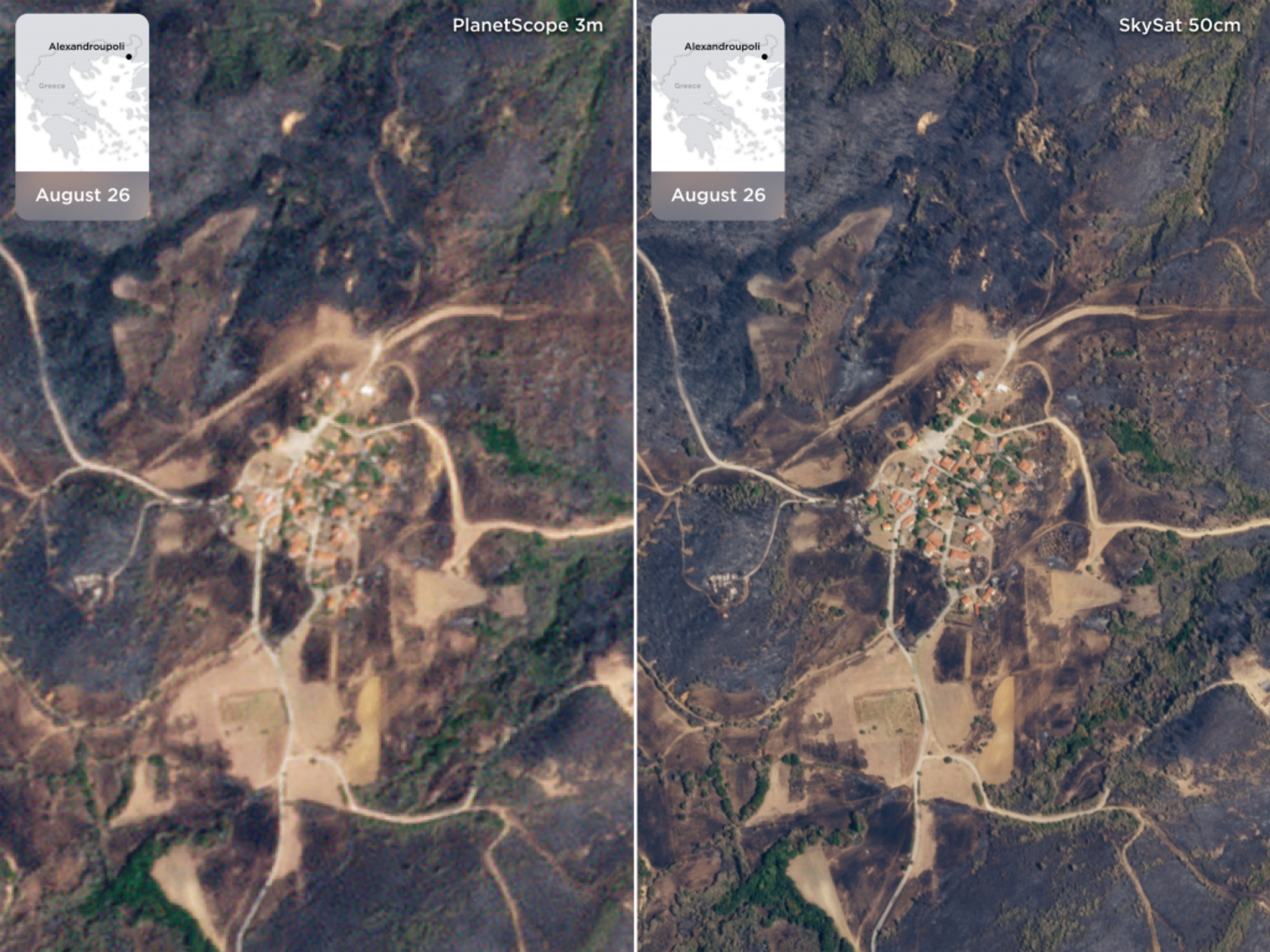
A comparison of PlanetScope and SkySat images of Alexandroúpolis, Greece illustrates the value of looking closer, in a higher resolution.
High-Resolution Tasking in Practice
By harnessing satellite imagery and advanced analytics, authorities have the ability to monitor and detect illegal activities such as deforestation, illegal mining, and wildlife trafficking. With global, high-frequency data, authorities are able to constantly monitor and identify suspicious behavior in remote areas, leading to more effective enforcement efforts.
Once the suspected activity is detected, high-resolution images can be easily tasked and received within hours, empowering policy makers and conservation organizations to see with more detail, make more informed decisions and take proactive measures to protect natural resources.

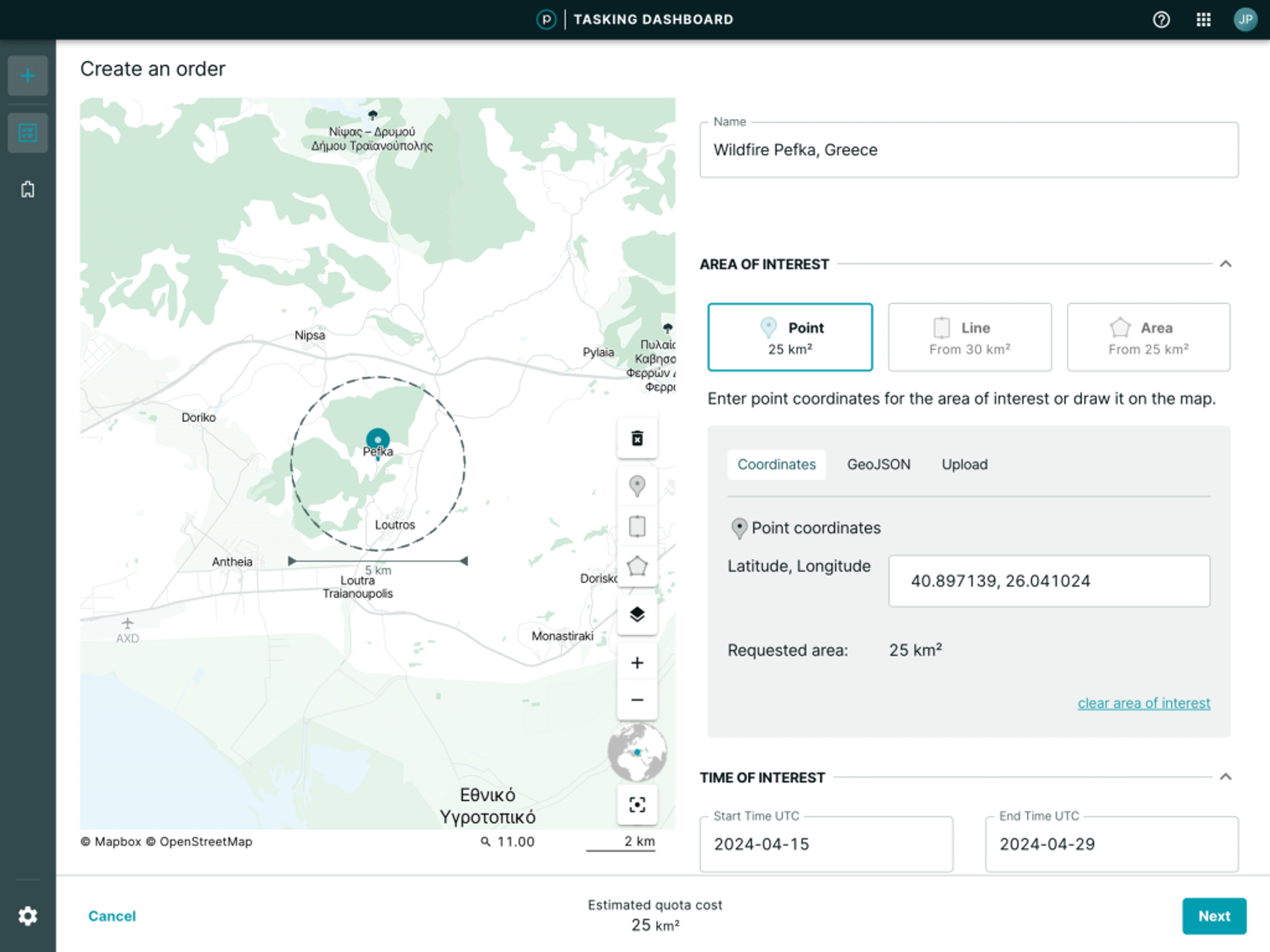
This tasking dashboard displays the area of interest (AOI) focused on Alexandroupolis, Greece.
This process of constant monitoring with always-on Earth observation data paired with on-demand high-resolution tasked imagery is called “tip and cue,” and it can be a powerful tool for organizations across industries.
- Urban planning and infrastructure development. High-resolution SkySat imagery provides urban planners and developers with a bird's eye view of cities and infrastructure projects. From assessing land use patterns to monitoring construction progress, these images offer invaluable insights for decision-making and efficient resource allocation.
- Agriculture and land management. In the agricultural sector, precise and up-to-date information is crucial for optimizing crop yields and managing resources effectively. High-resolution SkySat imagery enables farmers to monitor crop health, identify areas of pest infestation or irrigation issues, and make data-driven decisions to maximize productivity.
- Environmental monitoring and conservation. For environmentalists and conservationists, high-resolution SkySatimagery is a powerful tool for monitoring changes in ecosystems, tracking deforestation, and assessing the impact of human activity on natural habitats. This data is instrumental in designing conservation strategies and advocating for sustainable practices.
- Disaster management and emergency response. During natural disasters such as floods, wildfires, or earthquakes, timely and accurate information can save lives and mitigate damage. High-resolution SkySatimagery provides emergency responders and relief organizations with real-time updates on the extent of damage, helping coordinate rescue efforts and allocate resources effectively.
- Defense and intelligence. In the realm of defense and intelligence, high-resolution SkySat imagery plays a critical role in national security and strategic planning. From monitoring adversary activities to assessing the readiness of military installations, these images provide decision-makers with actionable intelligence to safeguard national interests.
Looking Closer With Planet
High-resolution SkySat satellite imagery provides the unprecedented ability to look closer at any area of interest. This is one of the core superpowers behind broad area management.
Interested in learning how looking closer can empower your organization to make better decisions? Watch our on-demand webinar that showcases how Planet can help your team achieve broad area management — and ultimately create a safer and more secure future.

Ready to Get Started
Connect with a member of our Sales team. We'll help you find the right products and pricing for your needs


