
Planet Data Helps Establish Scientific Rigor for SMARTFARM Carbon Monitoring Program
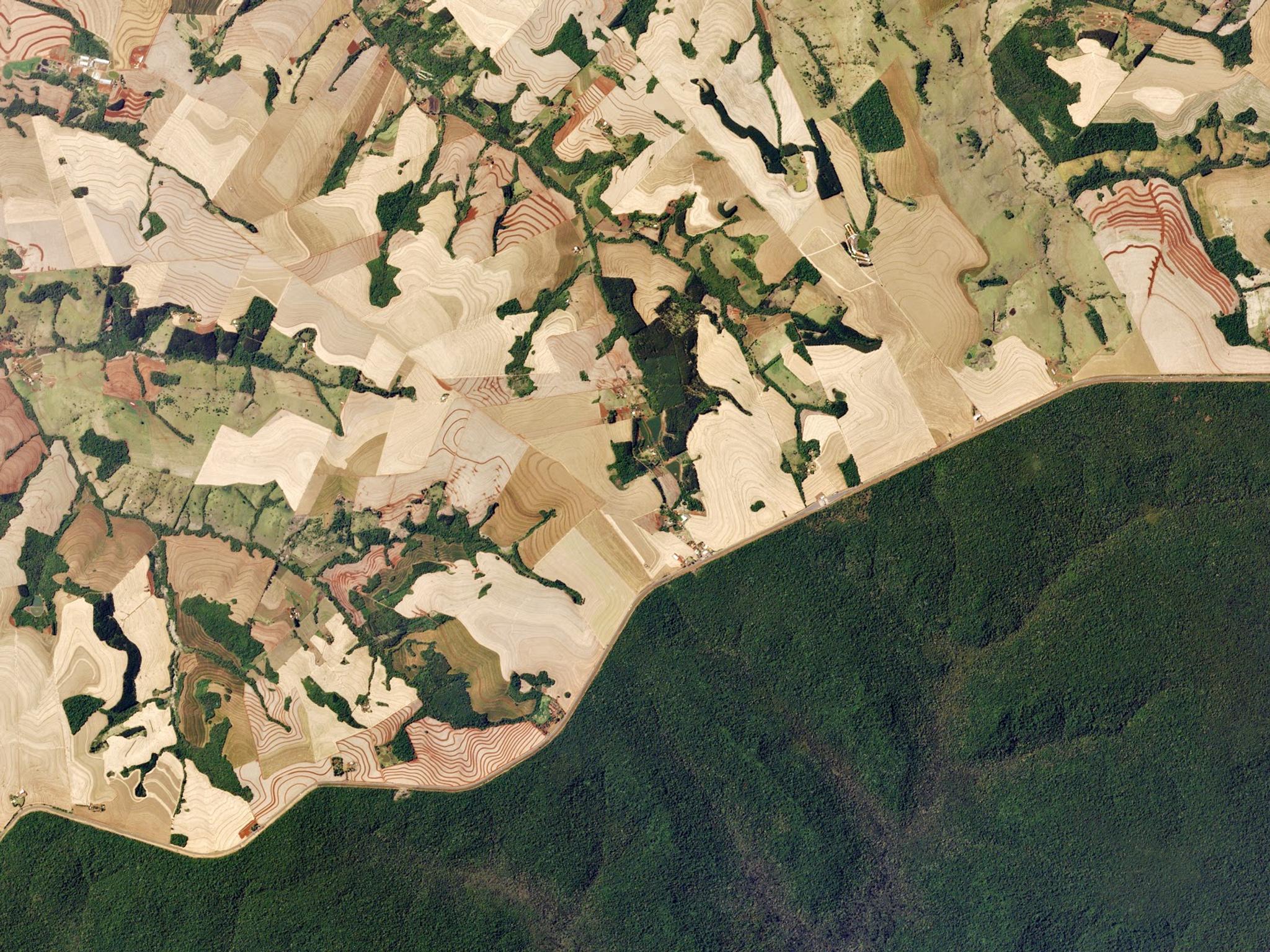
Highway 277 cuts through the southern Brazilian state of Paraná, dividing the lush green forest of Iguazú National Park from a patchwork of plowed sugar cane farms. © Planet Labs Inc. All Rights Reserved.
StoriesThe U.S. Corn Belt produces around 30% of all the corn and soybeans grown globally. These two crops, alongside rice and sorghum, makeup a large portion of biofuel crop yields within the U.S. and provide a low-carbon alternative to traditional fuel sources (coal and oil). Not only does this incredibly productive landscape provide this alternative, but research reveals that this agricultural land has immense potential to mitigate emissions through sustainable management and carbon monitoring practices.
A set of major efforts funded by the U.S. Department of Energy ARPA-E are leading the way in agricultural carbon monitoring initiatives including the SMARTFARM Program (Systems for Monitoring and Analytics for Renewable Transportation Fuels from Agricultural Resources and Management). This program aims to make it possible and profitable to optimize biofuel crops for yield and carbon capture intensity.
With this vision, SMARTFARM works in a two-phased approach, Phase 1 by setting scientifically rigorous baselines to better quantify soil conditions, and then Phase 2 by developing commercial tools to scale these measurements, which should help increase carbon offsets, and drive sustainable farming practices.
Dr. Kaiyu Guan, a Blue Waters Associate Professor at the University of Illinois at Urbana-Champaign (UIUC), works on a major component of this program through the newly founded UIUC Agroecosystem Sustainability Center with two SMARTFARM projects, one for Phase 1 and the other for Phase 2.
Guan’s SMARTFARM Phase 1 project measures carbon offsets by compiling and analyzing data on biofuel crops through a multi-layered approach at three commercial farmlands. The UIUC team conducts ground-based sampling measuring crop yield, soil chemistry, and water quality, then captures spatial-temporal variables at high resolution from both airborne hyperspectral imaging and satellite data analysis using data from various sources, including Planet data.
“Satellite data can provide useful information of crop and soil above ground,” said Dr. Kaiyu Guan who accessed Planet’s data through our Education and Research program. “The benefit of Planet data is it has a very high temporal frequency. For example, for the management practice, [Planet’s] spatial resolution is also helpful… and also has its reach at a global scale.”
Over the course of multiple years, the UIUC team led by Guan has taken agricultural data, like soil chemistry and crop photosynthesis rates, and scaled the data with images collected from their own airborne vehicle with a hyperspectral camera and satellite images.
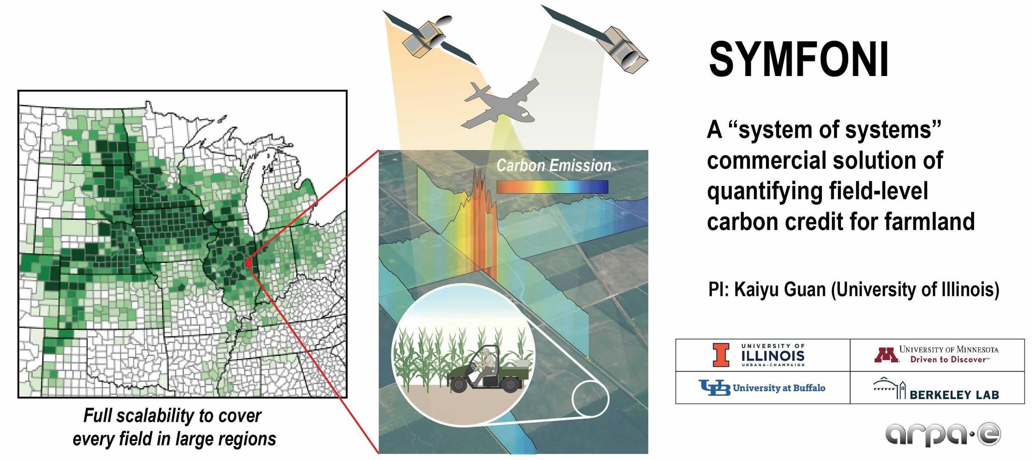
Guan’s SMARTFARM Phase 2 Project, named “SYMFONI”, aims to develop an unprecedented “system of systems” solution to quantify field-level carbon credit. This solution truly integrates different streams of remote sensing data and other sensor data with an advanced agroecosystem model, representing a comprehensive integration of data sets for accurate predictive modeling which can simulate energy, water, carbon, and nutrient fluxes.
Artificial intelligence and supercomputing can then be used to scale this solution to each of the millions of fields in the US and ultimately, globally.
.
Ready to Get Started
Connect with a member of our Sales team. We'll help you find the right products and pricing for your needs.