
Planet Partners Leverage Forest Carbon Monitoring
Our forests play a pivotal role in sequestering carbon and mitigating climate change. High-quality, regularly updated data on deforestation and carbon storage are crucial for the success of carbon markets and regulatory compliance. Planet Forest Carbon Monitoring offers insights into global changes in canopy height, canopy cover, and aboveground carbon density, delivering quarterly updates at a 3-meter resolution. This level of detail enables stakeholders to detect subtle changes in forest structure, supporting accurate monitoring, reporting, and verification (MRV) processes.
To maximize the impact of our Forest Carbon Monitoring product, we collaborate with specialized partners who integrate our data into their offerings. These partnerships enhance accessibility and usability for a diverse range of users, from carbon project managers to conservation organizations. The expertise and reach of our partners ensures that high-resolution forest carbon data is effectively utilized to drive sustainable outcomes and support global climate goals.
Empowering forest carbon monitoring through partnerships
Explore how BeZero Carbon, Cecil, SkyFi, Upstream Tech, and Earth Blox are integrating Planet’s Forest Carbon Monitoring data into their workflows.
BeZero
BeZero Carbon is a leading carbon ratings agency combining expert analysis, proprietary models, and geospatial data to evaluate risk and sustainability in carbon markets. Using Planet’s Forest Carbon Monitoring data, BeZero provides unparalleled insights into the permanence and additionality of carbon credits.
With a team of over 180 climate scientists, geospatial experts, and financial analysts, BeZero offers tools for every stage of the carbon project lifecycle. Customers, including project developers, investors, and government entities, access detailed ratings and risk analytics through the BeZero Carbon Markets platform.
BeZero’s transparency, independence, and research-first mindset make it an invaluable partner for driving confidence in carbon markets.
“Our scientists are leveraging the world’s first global 3-meter forest carbon datasets to build unique solutions for carbon ratings.” - Dr. Phil Platts, VP of Geospatial and Earth Observation, BeZero
Start your journey by exploring BeZero’s publicly available carbon ratings: https://bezerocarbon.com/ratings/listings
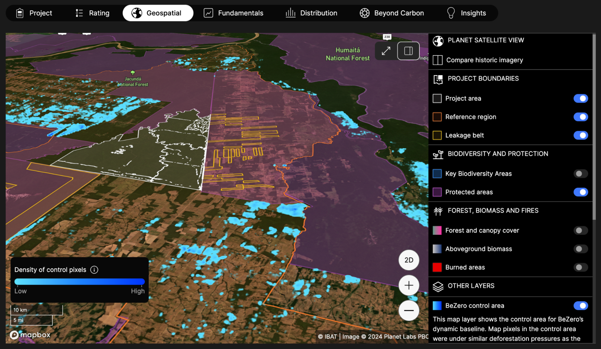
Geospatial analytics on the BeZero Carbon Markets platform. Blue heatmap shows the distribution of statistically matched control areas, constructed and monitored by BeZero to determine the additionality of carbon projects and strength of their carbon accounting. Project area mapped in white. Background imagery from Planet Labs (Q3’2024).
Cecil
Cecil makes nature data consistent, joinable, and ready for analysis with its platform built for data science and engineering teams. By curating high quality datasets, Cecil empowers users to perform large scale analyses without the need for building infrastructure or upfront pricing quotas.
Cecil’s Python SDK includes an API and analytical database, providing seamless access to datasets like Planet’s Forest Carbon Monitoring data. With Cecil data teams can securely connect their data operations and leverage a modern SQL database in their workflow to analyse time-series and spatial data at scale. There is no minimum spend or subscription to get started with Cecil, making high-quality datasets accessible to organizations of all sizes with usage-based pricing.
From nature-tech startups to large financial institutions, Cecil supports data scientists and engineers looking for accurate site-level data to monitor and evaluate natural assets. Plant biomass is the first scientific concept that Cecil has prioritised, and they have recently launched Land Use and Land Cover datasets.
“Data science and engineering teams around the world are quickly adopting Planet’s Forest Carbon datasets with many getting started on Cecil in days, not months.” - Alex Logan, CEO & Co-Founder, Cecil
Data science and engineering teams can get started with Cecil today - https://docs.cecil.earth/

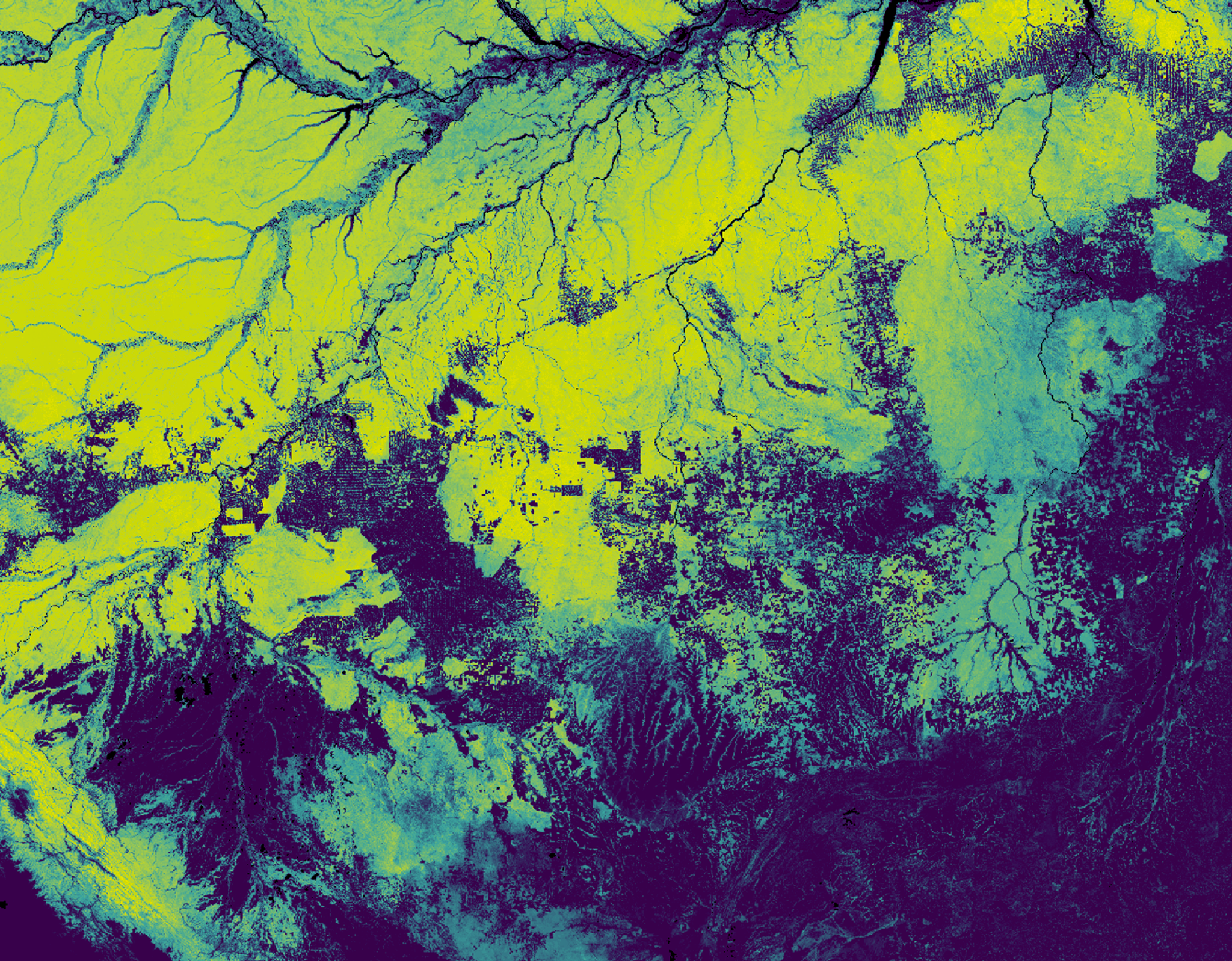
Analysis comparison between the Planet Forest Carbon diligence and monitoring dataset for the same AOI from 2021 to 2023. Credit to Sabine Nix, Cecil Spatial Data Scientist, who used Cecil's Python SDK to access datasets, and Python packages to plot the analysis and associated images.

Skyfi
SkyFi bridges the gap between advanced geospatial data and accessibility, enabling organizations to effortlessly monitor forest carbon. With Planet’s Forest Carbon Monitoring product integrated into its platform, SkyFi offers tailored datasets with transparent pricing and no long-term commitments.
SkyFi’s intuitive interface and flexible purchasing options make high-resolution carbon data available to a broader audience, including environmental organizations, governments, and carbon market participants. Customers can validate carbon projects, monitor forest health, and support sustainable outcomes with ease.
“SkyFi is transforming how organizations access and analyze forest carbon data. Through our platform, customers can purchase smaller, flexible datasets, expanding the reach of this critical solution to new audiences.” - Luke Fischer, CEO, SkyFi
SkyFi empowers users to drive climate action with accessible and actionable insights.
Request Forest Carbon Measurements from SkyFi today: https://skyfi.com/en/available-upon-request/forest-carbon-measurements
Planet's Forest Carbon Measurements are available upon request today on SkyFi. Soon the product will be available in-app for an up-front, seamless purchasing experience.
Upstream Tech
Upstream Tech is revolutionizing environmental monitoring through Lens, its user-friendly remote monitoring platform. Lens consolidates satellite and aerial imagery from public and commercial sources, including Planet’s Forest Carbon Monitoring data, into one tool for seamless visualization, analysis, and reporting.
Trusted by over 250 organizations managing 140 million acres globally, Lens empowers users to track landscape changes, visualize trends, and automate reporting without requiring technical expertise. Integrated access to multiple datasets, flexible ordering with no minimum area requirements, and extensive historical archives make Lens a powerful tool for scaling impact.
For carbon project managers, due diligence teams, carbon credit buyers, and conservation organizations, Lens offers actionable insights for monitoring, reporting, and verification (MRV). By delivering Planet’s data within minutes, Lens streamlines workflows and enhances decision-making for climate action and forest conservation goals.
“Planet’s 3-meter Forest Carbon Monitoring data is a transformative addition to the Lens Library, giving users a powerful way to track forest carbon changes at an unmatched level of detail and frequency.” - Abby Smith, Head of Product for Lens, Upstream Tech
Access Planet Forest Carbon Monitoring in Lens today: https://www.upstream.tech/lens/planet-3m-forest-monitoring
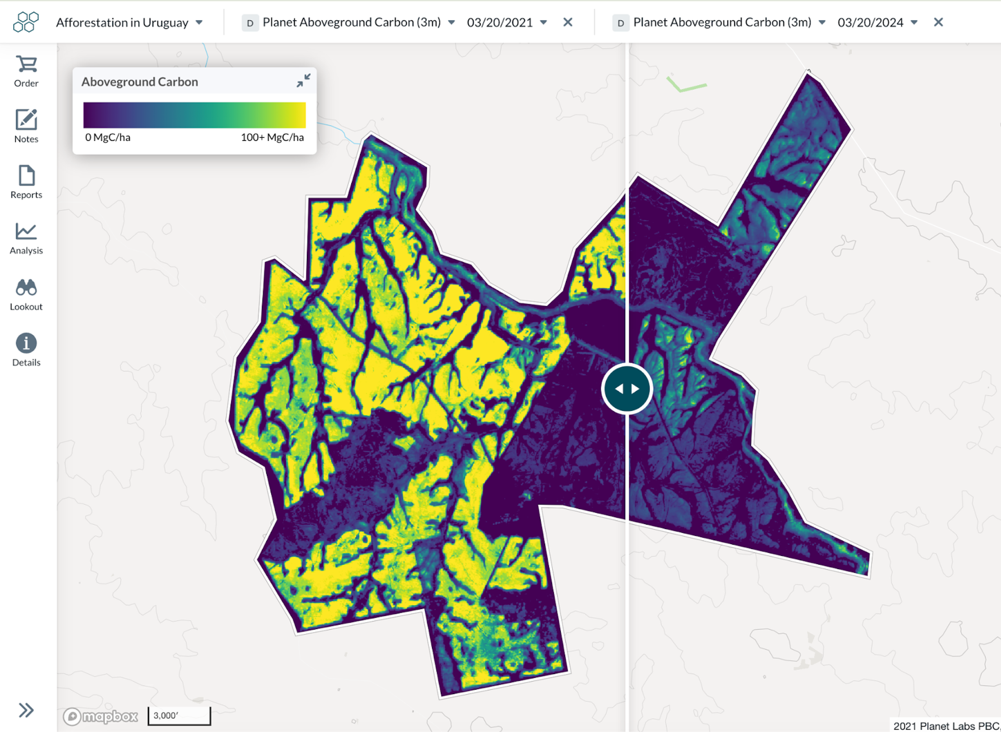
Planet Aboveground Carbon (3m) data in Lens
Earth Blox
Earth Blox is a geospatial SaaS platform that helps businesses manage climate and nature-related risks while ensuring compliance with evolving regulations. By providing access to authoritative satellite and geospatial data, Earth Blox enables organizations to analyze environmental impacts at scale.
Used by some of the world’s largest financial institutions, consulting firms, and energy companies, Earth Blox delivers transparent, auditable insights that support sustainability strategies, investment decisions, and regulatory reporting. The platform’s no-code interface and ready-made solutions make it easy for businesses to integrate geospatial intelligence into their operations, helping them navigate the transition to a more sustainable future.
"Partnering with Planet strengthens Earth Blox’s ability to deliver clarity in a complex sustainability landscape. By combining Planet’s high-resolution satellite imagery with our no-code platform, we give organizations direct access to critical environmental data, whether for risk assessment, compliance, or sustainability initiatives. Together, we are making geospatial intelligence more accessible, scalable, and impactful." - Mike Mason, COO of Earth Blo
Contact team@earthblox.io to access Planet data on Earth Blox
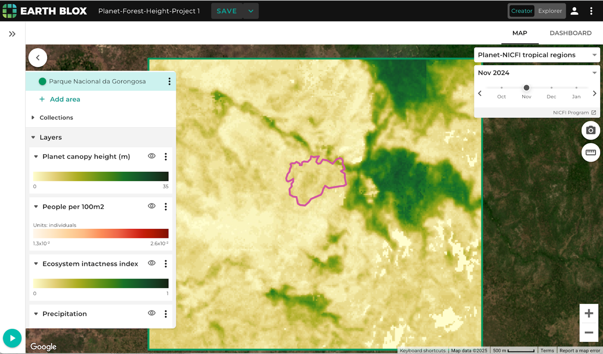
This assessment of a project area in Mozambique in Earth Blox uses Planet Canopy Height data alongside environmental and social map layers and is contextualized with a recent basemap. Additional layers can be incorporated for CSRD and EUDR reporting or for evaluating forest carbon projects.
Through these collaborations with partners BeZero, Cecil, SkyFi, Upstream Tech, and Earth Blox, we aim to empower organizations worldwide with the insights needed to protect and manage our forest resources, ultimately contributing to a more sustainable and resilient planet.
Ready to Get Started
Connect with a member of our Sales team. We'll help you find the right products and pricing for your needs