
Universal Access to Satellite Monitoring Paves the Way to Protect the World’s Tropical Forests
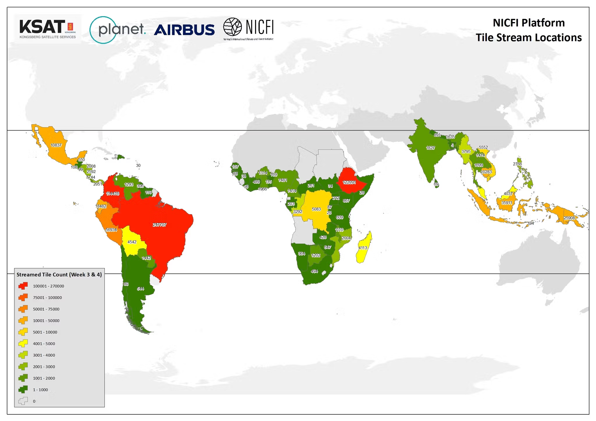
In September 2020, Norway’s Ministry of Climate and Environment awarded an international contract to Kongsberg Satellite Services (KSAT), who, in partnership with Planet and Airbus, have since been providing universal access to high-resolution satellite monitoring of the tropics to support efforts to stop deforestation and save the world’s tropical forests.
The contract is valued up to 405M NOK (~$43.5M, ~37M €). In these five months, the coalition of these geospatial organizations has been successful in advancing the mission of Norway’s International Climate and Forest Initiative (NICFI), which aims to protect the world’s tropical forests and provide sustainable pathways to economic development for tropical forest communities and countries. While there is a long way to go, we wanted to begin sharing stories that demonstrate how high-resolution satellite monitoring is being applied globally reduce deforestation in the tropics.
Under the UN-REDD Programme, The Republic of Congo is using Planet data to complete its national measurement and reporting to the United Nations Framework Convention on Climate Change. The national-scale data exercise relies on the provision of regular, cloud-free <5 meter satellite imagery to help assess changes in land cover and land use. Planet is especially helpful in the Congo, where traditional, less frequent Earth Observation datasets have been limited by cloud cover.
In Peru, the Ministry of Environment (MINAM) and the Forest Wildlife Service (SERFOR) are leveraging the data via the UN-REDD Programme to improve its Forest Reference Emission Level (FREL), a key benchmark for its measurement of the Amazon region and reporting to the United Nations Framework Convention on Climate Change. With a need to improve its deforestation estimates from 2007 to 2019, Peru has been able to take advantage of Planet’s cloud-free Basemaps, as well as the dates which are affiliated with each image, in order to provide accurate analyses of land use cover changes.
Ready to Get Started
Connect with a member of our Sales team. We'll help you find the right products and pricing for your needs.