Chin Lakes, Alberta Jun 06, 2015
How Planet's Distinctive Approach to Global Monitoring Sets a New Standard for Defense Analysts
Learn how broad area management with Planet helps defense analysts continually monitor change across every region of interest. Global military spending swelled to $2.24 trillion in 2023, according to analysis by the Stockholm International Peace Research Institute (SIPRI). “The unprecedented…...
Continue Reading
PLANET PULSE
Monitoring the pulse of our planet with daily news and imagery, stories, and tech updates.
Stories
AI-enabled Insights from Publications Leveraging Planet Data
Planet AI Symposium Curious to learn more on how the combination of AI and Planet's satellite data is helping to build a more sustainable and resilient world? Join us on, Thursday, January 30th for the Planet AI Symposium where industry…
CONTINUE READINGNews
Industry Leaders Join Planet AI Symposium: A Virtual Event Exploring the Future of “Geospatial Artificial Intelligence”
Today, we are proud to launch the Planet AI Symposium, a virtual event where leading experts join Planet to discuss the future of artificial intelligence. This event explores how the intersection of AI and Earth observation data could help build…
CONTINUE READINGTechnology
From Satellite Data to Actionable Insights: Predicting Hay Yield for North Dakota with Planetary Variables
Authors: Thomas Frederikse & Stephanie Gijsbers The ability to predict crop yields is essential for optimizing agricultural productivity, managing food security, and streamlining supply chain operations. Traditional forecasting methods often struggle with limited and inconsistent data, making it difficult to…
CONTINUE READINGDiscover how daily imagery brings insights for meaningful change
GO TO PLANET INSIGHTS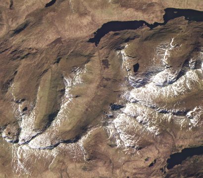
news
Planet and Esri UK Partner to Reveal Global Change with Unprecedented Visualization and Analytics
Planet is excited to announce our new partnership with Esri UK, a global market leader in geographic information system (GIS) software, location intelligence and mapping. The agreement will enable Esri UK to resell Planet imagery alongside powerful Esri ArcGIS visualization and analytical tools. Planet’s mission to image the entire Earth every day […]
CONTINUE READING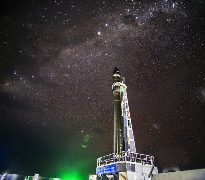
news
Pics or It Didn’t Happen: The Rocket Lab Launch of Five New SuperDoves
This June and July will be busy times for the Launch and Satellite Operations teams at Planet. In addition to the successful launch of three new SkySats this past Saturday (with three more launching this summer), we have another five SuperDoves (Flock 4e) launching on Rocket Lab’s “Pics or It Didn’t Happen” Electron launch later […]
CONTINUE READING
news
SkySats 16-18 Successfully Launch Aboard the SpaceX Falcon 9
On June 13, 2020, SpaceX’s Falcon 9 rocket successfully lofted three of Planet’s high-resolution imaging SkySats along with a batch of its Starlink communications satellites. SkySats 16, 17 and 18 were successfully deployed into a drop-off orbit of 205 x 380 km, 53 degree inclination. Planet’s launch operations team has successfully acquired […]
CONTINUE READING
news
Copernicus EMS Uses Planet Data for Emergency Response Mapping
We are excited to announce that the Copernicus Emergency Management Service, or Copernicus EMS, utilizes Planet data to help provide emergency response mapping services for a variety of disaster situations, ranging from geophysical and meteorological hazards to humanitarian and man-made crises. When events occur, authorized users can alert Copernicus EMS to an […]
CONTINUE READING
news
Planet Announces 50 cm SkySat Imagery, Tasking Dashboard and Up to 12x Revisit
Over the past year, Planet has seen increased demand for its SkySat imagery to fulfill customers’ needs for timely, accurate and frequent information across the decision cycle. The COVID-19 pandemic has intensified this trend, as traditional surveying and inspection methods are not currently possible. To meet the present moment, and demonstrate our […]
CONTINUE READING