Chin Lakes, Alberta Jun 06, 2015
How Planet's Distinctive Approach to Global Monitoring Sets a New Standard for Defense Analysts
Learn how broad area management with Planet helps defense analysts continually monitor change across every region of interest. Global military spending swelled to $2.24 trillion in 2023, according to analysis by the Stockholm International Peace Research Institute (SIPRI). “The unprecedented…...
Continue Reading
PLANET PULSE
Monitoring the pulse of our planet with daily news and imagery, stories, and tech updates.
Stories
AI-enabled Insights from Publications Leveraging Planet Data
Planet AI Symposium Curious to learn more on how the combination of AI and Planet's satellite data is helping to build a more sustainable and resilient world? Join us on, Thursday, January 30th for the Planet AI Symposium where industry…
CONTINUE READINGNews
Industry Leaders Join Planet AI Symposium: A Virtual Event Exploring the Future of “Geospatial Artificial Intelligence”
Today, we are proud to launch the Planet AI Symposium, a virtual event where leading experts join Planet to discuss the future of artificial intelligence. This event explores how the intersection of AI and Earth observation data could help build…
CONTINUE READINGTechnology
From Satellite Data to Actionable Insights: Predicting Hay Yield for North Dakota with Planetary Variables
Authors: Thomas Frederikse & Stephanie Gijsbers The ability to predict crop yields is essential for optimizing agricultural productivity, managing food security, and streamlining supply chain operations. Traditional forecasting methods often struggle with limited and inconsistent data, making it difficult to…
CONTINUE READINGDiscover how daily imagery brings insights for meaningful change
GO TO PLANET INSIGHTS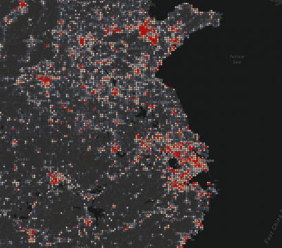
stories
Working Toward Planetary Scale Location Insights
Recent innovations in agile aerospace have created unique offerings in high cadence satellite imagery. While this is of immense interest to imagery analysts, a significant portion of GIS professionals and geo-data scientists work less with raster data (AKA imagery) and more with point and vector data. Planet operates the world’s largest constellation […]
CONTINUE READING
news
The Kincade and Saddleridge Fires, Dallas Tornadoes and Japan’s Typhoon
As natural disasters continue to leave their mark on communities and environments, satellite imagery is proving useful to journalists as they inform the public about these important events. Here are some examples of how satellite data can be utilized to help monitor environmental catastrophes. Kincade Fire Over a thousand firefighters are currently […]
CONTINUE READING
news
12 SuperDove Satellites Hitching a Ride to Orbit on the PSLV
Twelve of Planet’s latest-generation SuperDoves, Flock 4p, are scheduled for launch on November 20, 2019, joining the 26 SuperDove prototypes already in orbit. This Flock will hitch a ride on the Polar Satellite Launch Vehicle (PSLV), an expendable medium-lift launch vehicle designed and operated by the Indian Space Research Organisation (ISRO). As […]
CONTINUE READING
stories
What is Agile Aerospace? Learn Planet’s Approach
Agile aerospace is a philosophy of spacecraft development that encourages rapid iteration, where the aim is to make small improvements to every spacecraft design instead of exhaustively trying to perfect each one on the first try. The goal of this approach is to continue to optimize spacecraft architecture through an evolution of […]
CONTINUE READING
stories
The Sun Sets on a Successful Day at Explore 19
At Planet, our motto is, “See change. Change the world,” and we certainly saw and heard some Earth-shaking conversations and talks at the Explore 19 conference today. In his opening keynote, Planet CEO Will Marshall made a series of exciting announcements, like how our Next-Generation Dove satellites will deliver more spectral bands, […]
CONTINUE READING